Kathmandu/Beijing – Nepal and China on Tuesday December 8, said they had measured the height of Mount Everest at 8848.86 meters, thus ending a long-standing dispute over the altitude measurement of the tallest peak in the world.
The new height is 86 cm (2.82 feet) less than the widely accepted 8,848 meters, measured by India in 1955.
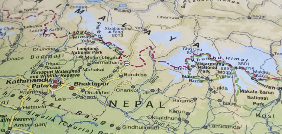
But for China, the mountain, which straddles the border between Nepal and Tibet at the crest of the Himalayan mountain chain, measured 8,844.43 meters.
Mount Everest is known in Nepali as Sagarmatha and Tibetan as Chomolungma.
Chinese Foreign Minister Wang Yi from Beijing and his Nepalese counterpart Pradeep Kumar Gyawali from Kathmandu announced the height of the peak in a joint virtual event streamed live.
It is the first time the two countries agreed on the height of Everest to end the debate about how high the roof of the world is.
With this joint announcement, the friendship between the two countries will reach “new heights,” said officials of the two countries who participated in the event.
It was a symbolic reference to the growing closer ties between the two countries that India, Beijing’s regional rival, views with concern.
“For Nepal, this is indeed a special moment for all of us. Mount Sagarmatha Chomolangma has remained an eternal symbol of good relationship and continued friendship between Nepal and China,” minister Gyawali.
The height of Everest has never been precise. It was measured for the first time in 1849 by the British.
Nepal had announced in 2011 to measure the height of the mountain in a “national pride” project, but it could not take off because of political instability and a lack of funds.
The project started in 2017, and Nepal used early traditional as well as new technologies to measure the heights.
Nepal’s survey team led by Khim Lal Gautam climbed Everest on May 22, 2019 and installed GPS equipment and ground-penetrating radar at the summit.
The Chinese team started surveying Everest with the BeiDou navigation satellite system of China last year.
It was during a visit by Chinese President Xi Jinping in October last year that Nepal and China agreed to announce the measurement jointly.
The Survey of India first measured the height in a project that continued from 1849 and 1855. The surveyors made observations from the Dehradun base to the Sonakhoda base in Bihar.
The peak was not recognized as the tallest mountain in the world then.
Surveyors employed trigonometric calculations to measure the height of what was known as “Peak XV.”
They set the mean computed height of the peak at 29,002 feet (8839.8 meters).
The peak got its name after Sir George Everest, the British geographer and ex surveyor-general of India, who led the team of surveyors.
In 2005, the Chinese Bureau of Topography and Cartography recalculated the peak using GPS and radar equipment and established its height almost four meters less than the widely recognized one.
China had previously measured the mountain only up to its rock height. The Nepalese argued the snow on top of the summit should also be measured.
The altitude agreement also settles the doubts that the mountain height may have changed due to the impact of the 2015 earthquake, measuring 7.5 on the Richter scale. The quake killed more than 9,000 people, including 19 on Everest.